
A marine heatwave (MHW) - a prolonged period of unusually warm sea surface temperatures - has been intensifying around the UK’s coastline, particularly the southern half, since February. By the end of May, sea temperatures were up to 2oC warmer than usual, peaking in the western English Channel, for this time of year.
What does the current marine heatwave look like?
In early June, the MHW deteriorated due to increased cloud cover and wind speeds. Following last week’s record-breaking UK temperatures, the majority of the Northwest European Shelf is experiencing a category I-III event. By the end of June, parts of UK waters were up to 5oC above average.
Dr. Zoe Jacobs, a scientist at the National Oceanography Centre (NOC), is closely monitoring this unfolding situation. In this article, she provides regular updates on how the MHW is developing, what the latest satellite data shows, and why it matters for UK marine ecosystems, fisheries, and communities.
Why does this matter?
Globally, MHWs have caused wide-ranging impacts on marine ecosystems. This includes the mortality of key species such as seagrass and kelp, the mortality or reorganisation of commercial fisheries and the initiation of harmful algal blooms (HABs).
The biological and societal impacts of this MHW are currently unknown. However, impacts may emerge over the coming weeks, including affecting the timing and size of phytoplankton blooms (base of the marine food chain), potentially reducing or boosting their productivity. It’s possible that Harmful Algal Blooms could be triggered, which can produce toxins harmful to marine life and the environment.
It may also lead to a temporary disappearance of cool-water species and emergence of warm-water species or the disruption of marine species’ life cycles , impacting their growth or reproduction. All of this may impact the regional marine ecosystem, fisheries and the economy in different ways.
With climate change continuing to raise global temperatures, it’s vital that these occurrences are monitored, and that we have more targeted research to understand these impacts to improve UK resilience to MHWs.
VIEW THE DATA
Access reprocessed and near-real-time OSTIA sea surface temperature data via the NOC OceanDataStore at the following link: OceanDataStore
- Download near-real-time satellite remote sensing data at the following link: Sea Surface Temperatures
Rolling Updates: Marine Heatwave Monitoring
Read our updates below on the developing MHW around the UK using satellite maps of sea surface temperature (SST) and chlorophyll-a concentrations - an indicator of how much phytoplankton is present in the water.
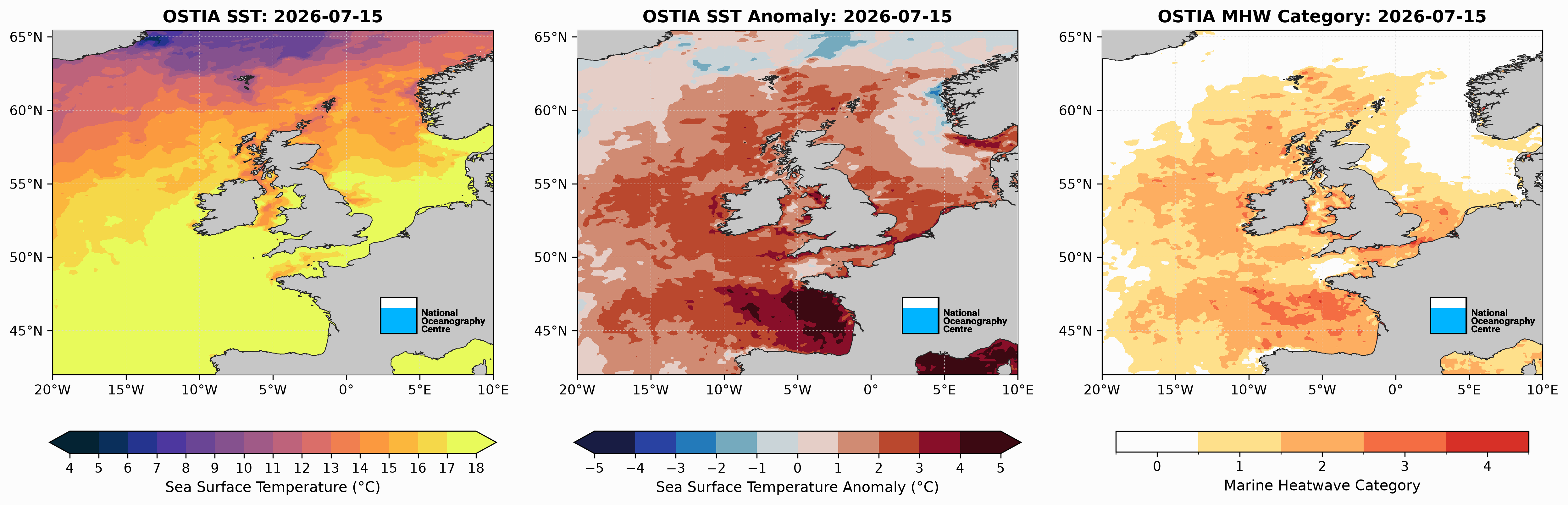
Latest: Sunday 19 July
On Sunday 19th July, while the category I-III MHW is persisting across UK seas, there are signs that it is declining, particularly in the central and northern North Sea, with temperatures now just 0-2oC warmer than usual for this time of year.
There is also a cooler (up to -5oC) pool of water off the coast of Norway, which appears to be spreading southwest into the North Sea.
However, the southern North Sea, Irish Sea, central and eastern English Channel remains 2-3oC warmer than usual and is classified as a category I-III MHW. SST anomalies of +1-4oC remain around Ireland, particularly the southern part, with signs of this reducing further north and around the Scottish coast.
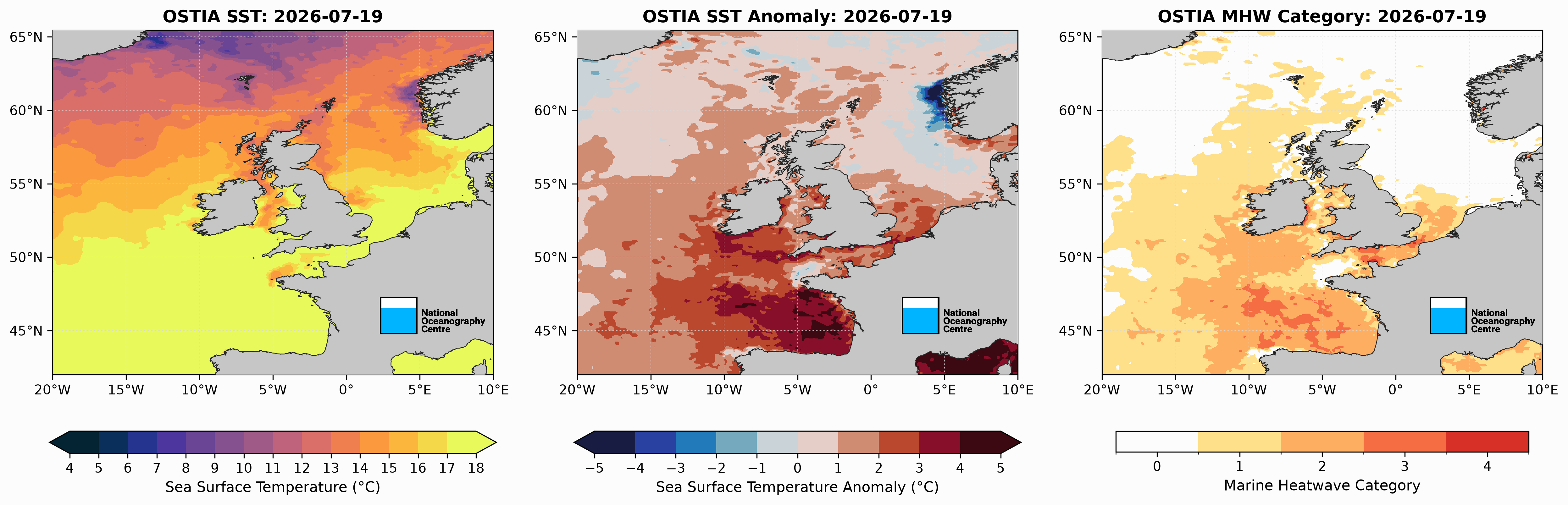
19/07/25: Sea Surface Temperature (left), respective anomalies (middle) and Marine Heatwave category (right). Calculated using the 0.05o daily OSTIA Sea Surface Temperature product using a baseline of 1982-2011. https://data.marine.copernicus.eu/product/SST_GLO_SST_L4_NRT_OBSERVATIONS_010_001/description
It’s time for an update on what’s happening beneath the surface.
First, measurements from CTD downcasts from the RRS James Cook, which is still located around the shelf edge to the southwest of the UK.
As we have seen from the most recent updates (11th, 15th and 19th July) temperatures remain up to 4oC warmer than usual in this region. After travelling south to around 46oN, the RRS James Cook moved back north to Whittard Canyon (13th July) where water is climatologically cooler due to enhanced mixing at the shelf edge. However, it is still 2-3oC warmer than usual with the climatological surface temperature located close to 20m. By 15th and 18th July, this is closer to 40-50m below the surface, with surface temperatures peaking at ~3.5oC warmer than usual.
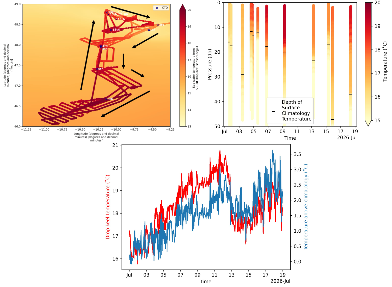
Top left: Sea temperature (measured from the keel, around 5m below the surface) collected by RRS James Cook between 29th June-18th July on its journey around Whittard Canyon (at the shelf edge to the southwest of the UK), overlaying the climatological surface temperature from Copernicus. Top right: Temperature at depth (up to around 50m) measured by CTD downcasts from 1st-18th July, the black line on each is the depth of the surface climatological temperature. Bottom: Sea temperature (red) and anomalous sea temperature (blue) from 1st-19th July. The ship moves south from 3rd-9th July and back north around Whittard Canyon between 13th and 18th July (see top left panel for position of the ship on each date). Figures provided by Harry Ashton-Key (UoS).
The Met Office Glider (MOGli) is currently located at the opposite end of the UK, to the northeast of Scotland.
Last week we saw a category I MHW starting to spread northwards in the North Sea. The glider reveals surface temperatures of up to 3oC warmer than usual were occurring by 16th July, which is a category II MHW. It also shows that these temperatures were occurring at depths approaching 40m.
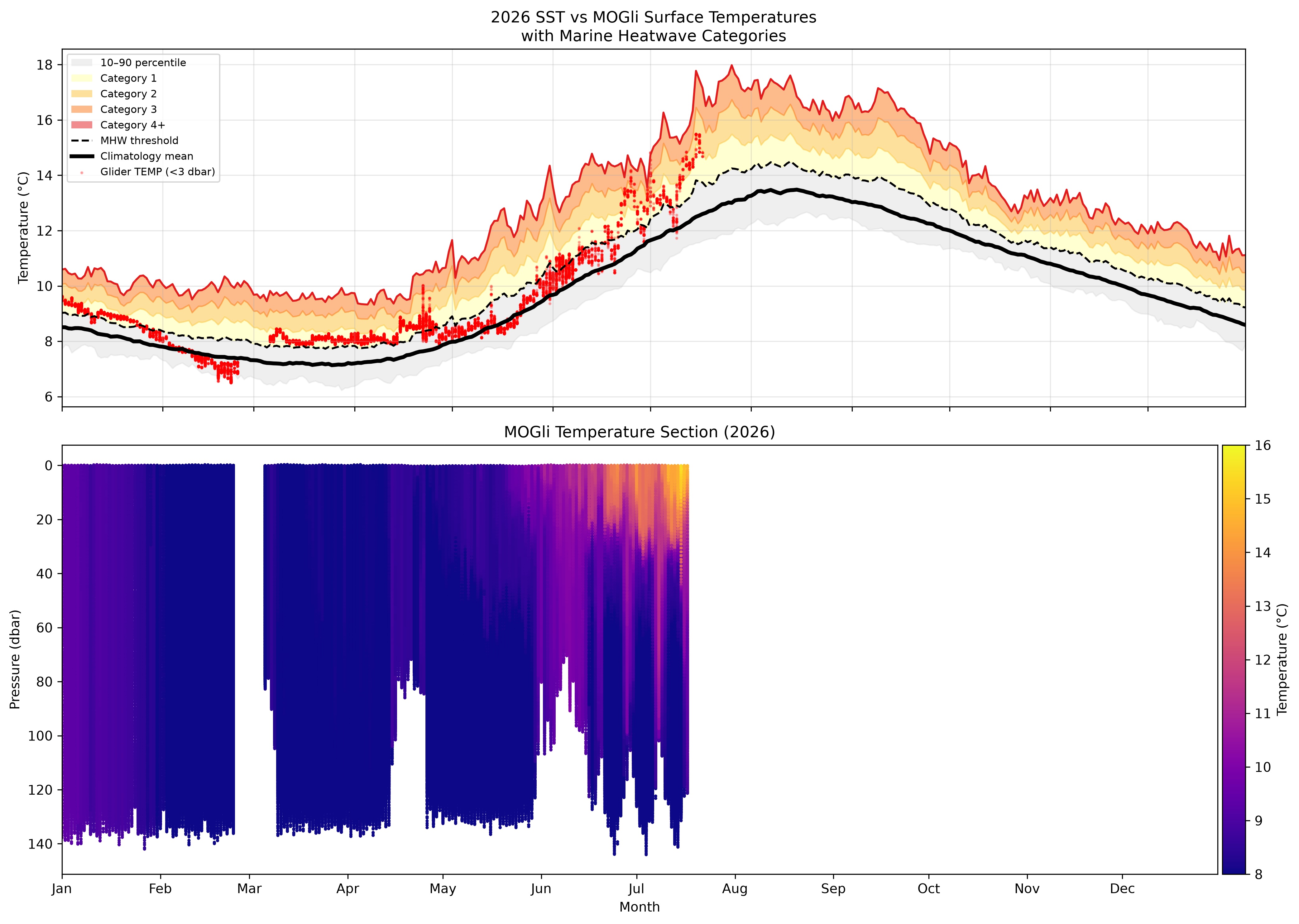
Top: Climatological sea surface temperature recorded by satellite (black line), and the Met Office Glider (MOGli; red markers) for 2026 to the northeast of Scotland (see bottom right panel for location). MHW categories overlaid in shades of orange. Bottom left: Subsurface temperatures recorded by MOGli. Figures provided by Dr Charlotte Williams (NOC).
Thursday 16 July
15/07/26: Sea Surface Temperature (left), respective anomalies (middle) and Marine Heatwave category (right). Calculated using the 0.05o daily OSTIA Sea Surface Temperature product using a baseline of 1982-2011. https://data.marine.copernicus.eu/product/SST_GLO_SST_L4_NRT_OBSERVATIONS_010_001/description
The MHW is now occurring near the long-term monitoring site at the Porcupine Abyssal Plain in the Northeast Atlantic.
The below figure shows the daily sea surface temperature for each year since 2014. The intense MHW that peaked west of Ireland during June 2023 is clearly visible, with the event that occurred in August 2025 also indicated. This year (the bold red line), the temperature doesn’t appear to be as high as in previous years, but it is increasing (reaching 17.78oC on 16th July), concurrent with the developing MHW.
Dr Sue Hartman from the National Oceanography Centre explains what measurements are taken from this site, why this is important and what we could learn about MHWs in this region: "The PAP-SO (Porcupine Abyssal Plain Sustained Observatory) is one of the longest running deep ocean timeseries sites, with measurements from the surface to depths of 4850m going back to the 1980s.
"It includes a time series of biogeochemical data that has delivered high resolution data on temperature, salinity, oxygen, carbon dioxide and nutrients, in near real time, since 2002 (in partnership with the UK Met Office). PAP-SO is representative of the productive northeast Atlantic, a strong sink region for atmospheric carbon dioxide.
"MHWs are clearly seen in the PAP-SO data and may impact the carbon dioxide sink, dissolved oxygen concentrations and productivity through to fisheries. More information on PAP-SO can be found at https://projects.noc.ac.uk/pap/."
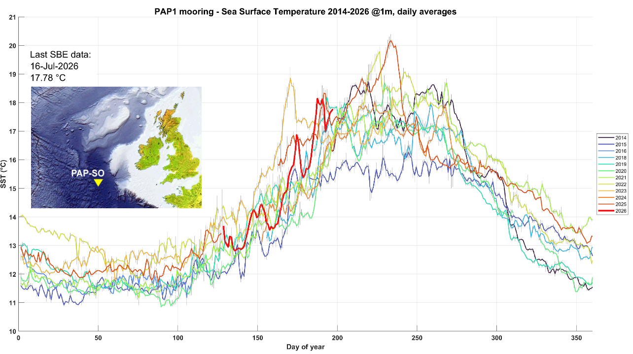
Daily sea surface temperature measured from the Porcupine Abyssal Plain Sustained Observatory (48° 50′ N, 16° 30′ W) since 2014 (latest data point 16th July 2026). Each year is represented by a different coloured line, the bold red line is 2026.
Tuesday 14 July - Topical Highlight: Jellyfish

Saturday 11 July
On Saturday 11th July, temperature anomalies continue to increase across the North Sea as the category I MHW spreads northwards along the eastern English coast and into Scottish waters. SST anomalies range from +1-4oC across this region, with +3oC anomalies widespread in the southeast North Sea (category II).
The largest anomaly in the western English Channel has reduced in spatial extent, with anomalies exceeding +5oC now confined to the Dorset, Devon and Cornwall coasts, which remain classified as a category II-III MHW. However, there is a small region from West Bay to Weymouth that is classified as a category IV ‘Extreme’ MHW.
The Celtic and Irish Seas are currently experiencing enhanced warming with anomalies of +2-4oC (category I-II) prevalent throughout the region. The ocean west of Ireland has also rapidly switched from cool (-1-2oC) to warm anomalies (+1-2oC) over the last three days with a category I MHW developing.
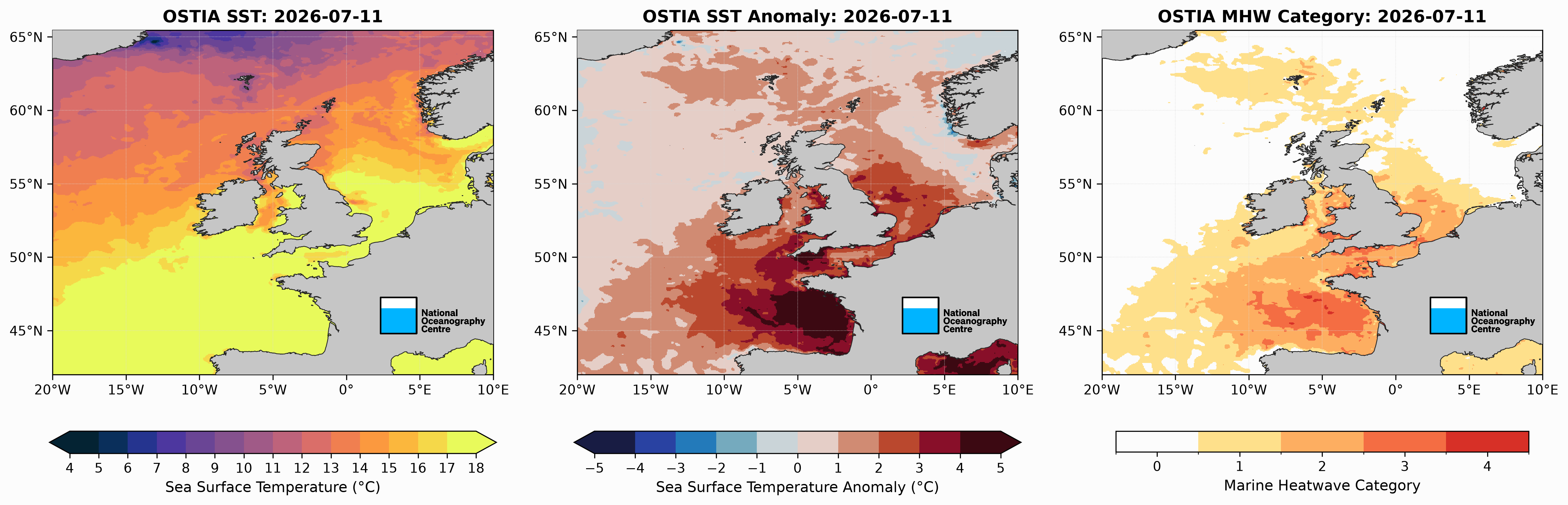
11/07/25: Sea Surface Temperature (left), respective anomalies (middle) and Marine Heatwave category (right). Calculated using the 0.05o daily OSTIA Sea Surface Temperature product using a baseline of 1982-2011. https://data.marine.copernicus.eu/product/SST_GLO_SST_L4_NRT_OBSERVATIONS_010_001/description
An update from the RRS James Cook:
The map below shows the position of the RRS James Cook as it conducts research around Whittard Canyon with waters consistently 2-3oC warmer than usual (measured at the keel) as it passed through the category I-II MHW. The time series (bottom right) highlights the rapid increase, from ~16-19.5oC, over the first week of July (1st-7th) before plateauing at around 19.5oC. This is likely due to a combination of travelling south into warmer waters from ~48.5oN to 46.5oN, and due to the developing MHW in the western Bay of Biscay.
What’s happening below the surface? Downcast CTD data over the top ~30m shows the progressive (1st-9th July) warming at the surface but also at depth as the ship travelled further south, with 19-20oC waters reaching ~15m by 9th July.
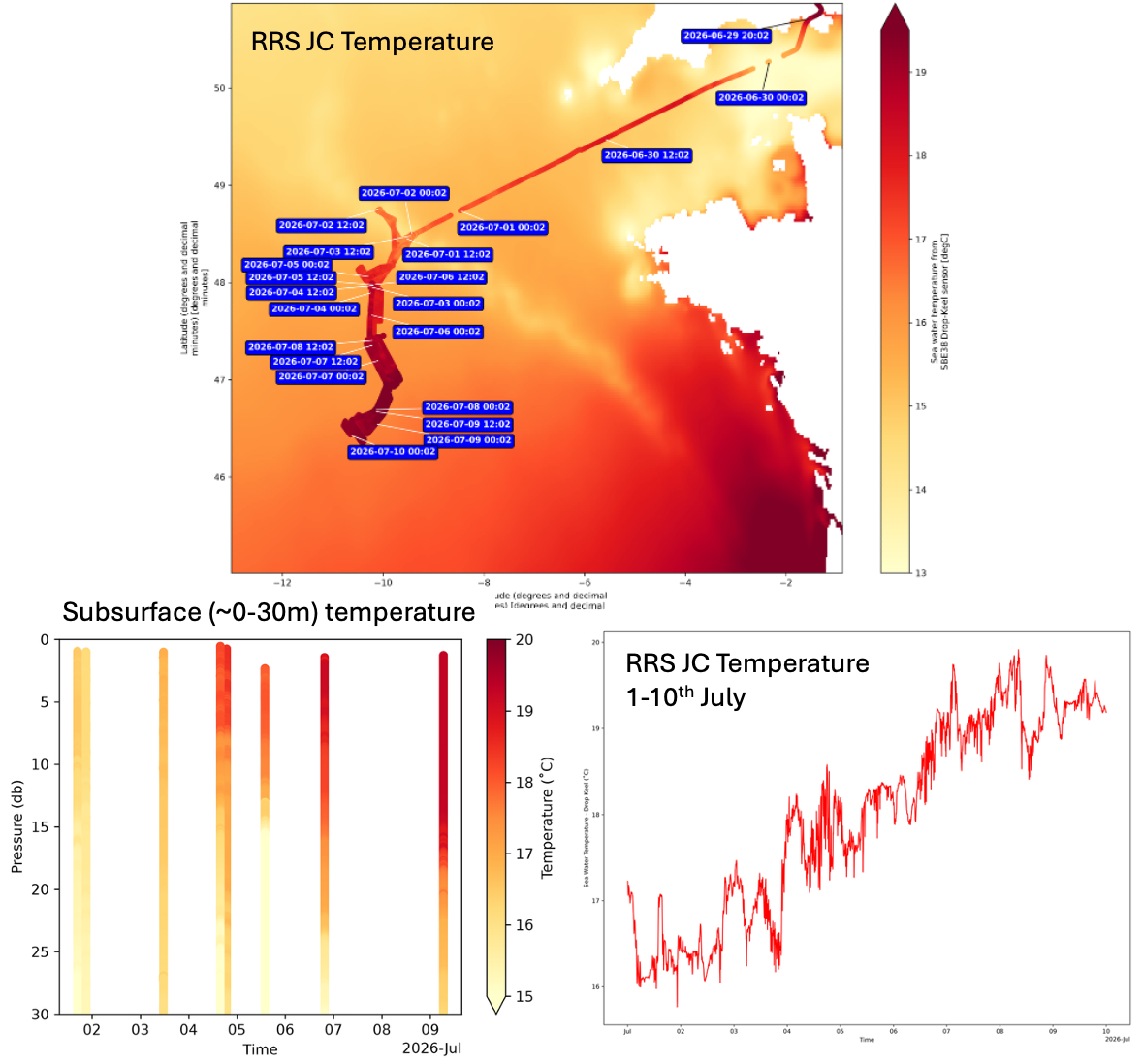
Top: Sea temperature (measured from the keel, around 5m below the surface) collected by RRS James Cook between 29th June-10th July on its journey to Whittard Canyon from Southampton, overlaying the climatological (June 1994-2025) SST from Copernicus. Bottom right: As above but from 1-10th July.
Bottom left: Temperature at depth (up to around 30m) measured by downcast CTDs from 2nd- 9th July, getting progressively further south (see top for dates).
Figures provided by Harry Ashton-Key.
Wednesday 8 July
On Wednesday 8th July, SST anomalies have increased across the entire region. The larger anomalies remain in the western English Channel with warming of >5oC greater than usual (category III-IV). This warming is spreading across the Channel and in the southern North Sea, with the majority of the region now experiencing widespread anomalies of +3-4oC (category II-III), particularly around the southeast coast of England, in the Thames estuary and off the Lincolnshire coastline. Earlier in the week the SST anomalies were declining in the central and northern North Sea as warmer water was mixed down the water column. Now these winds have reduced, the surface anomaly has started to intensify again with anomalies of 2-3oC now occurring across the region, except around Norway, which continues to cool. Part of the Irish Sea (west of Wales) is no longer experiencing a MHW but anomalies continue to increase (+3-4oC) off the northwest coast of England, now at category I-III. It is also worth highlighting that small pockets of water are now categorised as a category IV MHW, which is highly unusual for UK waters.
Dr Ségolène Berthou from the UK Met Office outlines what we can expect over the coming week:
"MHW conditions are building up this week for all regions around the UK, with widespread anticyclonic conditions forecast until the middle of next week (extended Azores high). Marine heatwave conditions are long-lasting, the domain-average MHW will be at least 1 month-long (it’s already 15 days). Pockets of extreme levels (usually >4-5°C anomalies) have been recorded in the western English Channel. Scottish and Northern Irish waters are likely to enter MHW conditions next week."

08/07/25: Sea Surface Temperature (left), respective anomalies (middle) and Marine Heatwave category (right). Calculated using the 0.05o daily OSTIA Sea Surface Temperature product using a baseline of 1982-2011. https://data.marine.copernicus.eu/product/SST_GLO_SST_L4_NRT_OBSERVATIONS_010_001/description
Sunday 5 July
On Sunday 5th July, SST anomalies continue to decline in the northern, central and eastern North Sea, with negative anomalies occurring around Norway, such that the majority of these regions are no longer classified as experiencing a MHW. Greater anomalies (up to +3oC) remain in the southwestern North Sea where the MHW remains a category I-II event. Most of the English Channel & Irish sea continue to experience a category II MHW with anomalies largely unchanged (+2-3oC) from last week. However, surface warming has increased in the western English Channel, and further south in the Bay of Biscay with anomalies reaching +3-4oC. Contrastingly, waters to the west of Ireland are experiencing cooler (0-2oC) waters than usual for this time of year, which was the site of the most intense SST anomalies during the June 2023 MHW.
05/07/25: Sea Surface Temperature (left), respective anomalies (middle) and Marine Heatwave category (right). Calculated using the 0.05o daily OSTIA Sea Surface Temperature product using a baseline of 1982-2011. https://data.marine.copernicus.eu/product/SST_GLO_SST_L4_NRT_OBSERVATIONS_010_001/description
While remotely sensed data from satellites are useful to understand the large-scale, long-term changes to SST, they don’t provide the whole picture, particularly at the coast.
John Pinnegar, Principal Scientist and Lead Advisor for Climate Change at Cefas said:
"Cefas’ datasets, including those from the more recent WaveNet and SmartBuoy networks, provide a century-long record of real-time sea surface temperature data, helping us understand events such as this marine heatwave in their historical context. While satellites show what is happening at scale, our buoys located across 72 sites in the UK provide continuous measurements from the water itself, feeding into Met Office forecasts and long-term reporting. By combining these observations with modern remote sensing and working closely with our partners, we can build a clearer picture of how this event is evolving — and what it means for the ecosystems, industries and communities that depend on our seas."
For example, last week some of their SmartBuoys recorded considerable anomalies, including +5.3oC at Hastings (see below Figure) with a number of other sites measuring anomalies exceeding 4oC, including at Poole Bay (+4.1oC), Liverpool Bay (+4.6oC) and South Knock in the Thames estuary (+4.3oC).
Year-round sea surface temperature measured from a Cefas SmartBuoy at Hastings. Individual lines correspond to years from 2002-2026, the red line is 2026, the orange line is the climatology and the shaded orange is the 95th percentile. https://wavenet.cefas.co.uk/
Opportunistic sea temperature measurements can also be obtained from vessels, including that from the keel of the RRS James Cook, which measured sea temperatures from 29th June-3rd July (see below Figure) on its way to Whittard Canyon. It measured temperatures exceeding 18oC as it passed through the MHW, classified as category I-II at the time, which was much warmer than climatological conditions. The ship is scheduled to return to Southampton on 3rd August where it will capture information on variables including temperature, oxygen and chlorophyll-a concentrations (watch this space).
Sea temperature (measured from the keel, around 5 m below the surface) collected by James Cook between 29th June-3rd July on its journey between Southampton and Whittard Canyon, overlaying the climatological (June 1994-2025) SST from Copernicus. Figure provided by Harry Ashton-Key.
Thursday 2 July 2026
On Thursday 2nd July, the SSTs on the Northwest European Shelf have cooled slightly, where anomalies are now 0-4oC warmer than usual. This has reduced the MHW classification so that the northern North Sea and Celtic Sea are no longer experiencing a MHW with reduced anomalies of +0-2oC. However, the central English Channel, southwest North Sea and parts of the Welsh coastline remain in category II MHW conditions, while the central North Sea, Irish Sea and western English Channel are largely classified as a category I MHW. The largest SST anomalies (up to +4oC) are occurring along parts of the eastern English coastline, with many other English and Welsh coastlines experiencing anomalies of up to +3oC.
Why have we seen a slight deterioration of the MHW? Dr Ségolène Berthou from the UK Met Office explains:
"Our ocean forecasts indicate that the warm anomaly has started to sink to greater depths because of strong northwesterly winds, particularly in the central and northern North Sea. The English Channel, Irish Sea and southern North Sea remain in MHW conditions, as they are shallower and fully mixed. However, with the more settled conditions coming this weekend and next week, MHW conditions are likely to return or strengthen in all regions."
02/07/25: Sea Surface Temperature (left), respective anomalies (middle) and Marine Heatwave category (right). Calculated using the 0.05o daily OSTIA Sea Surface Temperature product using a baseline of 1982-2011. https://data.marine.copernicus.eu/product/SST_GLO_SST_L4_NRT_OBSERVATIONS_010_001/description
Monday 29 June 2026
On Monday 29 June, most of the Northwest European Shelf was experiencing at least a category I moderate MHW, where SSTs were 1-5oC warmer than usual. The North Sea and parts of the English Channel appear to be experiencing the greatest warming with widespread anomalies of 3-5oC as temperatures rise to more than 18oC, reaching category II (strong) classification. Parts of the UK coastline are currently up to 4oC warmer than usual including south Devon and near the Thames estuary, with warming of up to 3oC apparent around the southeast coast, in the western English Channel and parts of the northwest Welsh and English coastlines.
The event is currently most intense around the southern part of the UK with smaller anomalies of 1-2oC currently occurring around Scottish, Irish and northeast English coastlines.
With UK air temperatures set to rise to above 30oC in some regions by early next week, the MHW is likely to persist or intensify.
29.06.26: Sea Surface Temperature (left), respective anomalies (middle) and Marine Heatwave category (right). Calculated using the 0.05o daily OSTIA Sea Surface Temperature product using a baseline of 1982-2011.
View the data
Download near-real-time satellite remote sensing data at the following link:
Be part of the community helping our ocean thrive.
UK Marine Heatwaves Explained (Why our seas are warming)
Our seas are warming at an unprecedented rate.
Just like heatwaves on land, we get them in the ocean too. In this quick breakdown, oceanographer Dr. Zoe Jacobs from the National Oceanography Centre explains the severe, successive marine heatwaves hitting UK waters.

Related Resources
Learn more about marine heatwaves and NOC's research aimed at learning more about their behaviour below. This includes educational pages and latest news.


What Do We Know About Marine Heatwaves Around the UK?
A study led by NOC's Dr Zoe Jacobs revealed where marine heatwave events are most likely to occur in UK waters, for the first time. Published in Frontiers in Marine Science, it shows there are regional marine heatwave hotspots in the Southern North Sea and English Channel. Events here are weaker than in other areas around the UK, but last longer.